 Asset Publisher
Polish forests
 fot. Paweł Fabijański
 fot. Paweł Fabijański
 fot. Paweł Fabijański
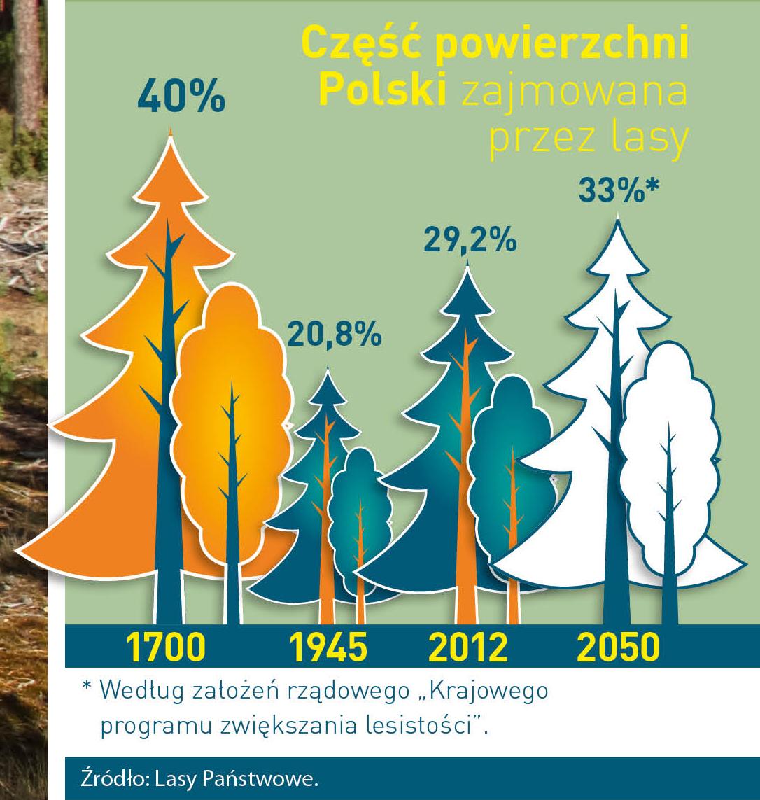
Poland is in the European lead, while concerning the area of all forests. They cover about 29,2 % of the country territory, and grow within the area of 9,1 million hectares. The overwhelming majority of the forests is state owned, of which almost 7,6 million hectares are managed by the State Forests National Forest Holding..
The number of Polish forest is still growing. The forestation rate of the country has increased from 21 % in 1945 to 29,2 % at the moment. Between 1995 and 2008, the forest area increased by 310 thousand ha. The basis for afforestation works is the "National Programme for Increasing the Forest Cover" (KPZL), assuming an increase of the forestation rate up to 30 % by 2020 and up to 33 % by 2050. Polish forests abound in flora, fauna and fungi. 65 % of the total number of animal species live there.
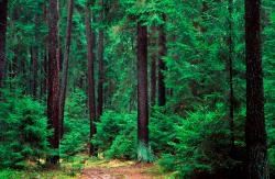
The forests grow in our country on poor soils, mainly because of the development of the agriculture in previous years. It influences the distribution of the types of the forest sites in Poland. Over 55 % of the forest areas is covered with coniferous forests. In other areas, there are forest sites, mainly the mixed ones. Their small part constitute alder and riparian forests – not more than 3 %.
In the years 1945 – 2011 the area of natural deciduous tree stands within the area of the State Forests National Forest Holding increased from 13 to 28,2 %.
Within the lowlands and uplands the most often occurring tee species is pine. It covers 64,3 % of the forest area of the State Forests National Forest Holding and 57,7 % of private and commune forests. In the mountains the predominant species is European spruce ( in the west) and European spruce with beech (in the east). Domination of pine is the result of carrying on sustainable forest management in the past. Once, the monocultures (crops or cultivations of one species) were the answer to the great demand of industry for wood. Such forests appeared to be quite fragile to climatic factors. They also were often the prey of pests' expansion.
In Polish forests, the share of other tree species, especially deciduous trees have been systematically increasing. The foresters have stepped aside from monocultures – that is why, they try to fit specific species of the forest stand to the natural stand, that would be proper for the given area. Thanks to that, in the years 1945 – 2011, the area of the deciduous tree stands within the lands of the State Forests National Forest Holding increased from 13 to 28,2 %. There occur more and more frequently the following tree species: oaks, ashes, maples, sycamore maples, elms, but also birches, beeches, alders, poplars, hornbeams, aspens, tilias and willows.
Our forests are the most often represented by the forest stands aged 40 to 80 years. The average age of the forest equals 60 years. More and more trees are of big size at the age over 80 years. Since the end of the Second World War, the forests' area has increased up to almost 1,85 million hectares.
Raport o stanie lasów w Polsce 2012
Asset Publisher
Retencja w Nadleśnictwie Oleśnica Śląska
Retencja w Nadleśnictwie Oleśnica Śląska
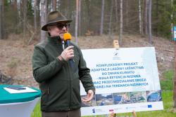


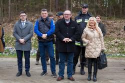

22 kwietnia 2022 roku w Twardogórze uroczyście otworzyliśmy obiekty retencyjne, które znajdują się na terenie lasów Nadleśnictwa Oleśnica Śląska. Nazwa projektu: „Kompleksowy projekt adaptacji lasów i leśnictwa do zmian klimatu - mała retencja nizinna oraz przeciwdziałanie erozji wodnej na terenach nizinnych”.
Leśnicy w Lasach Państwowych od ponad 20 lat realizują działania związane z retencją wodną. W tym czasie, w lasach, powstało prawie 15 tys. różnorodnych obiektów, które retencjonują ponad 50 mln m3 wody. Dzisiaj wzbogacamy lasy o kolejne 31 obiektów, które powstały dzięki zaangażowaniu Pracowników Nadleśnictwa Oleśnica – i to od momentu pomysłu, wizji, projektowania, nadzoru, czy też rozliczenia finansowego tej skomplikowanej inwestycji. Dziękuję Wam serdecznie za dobrą pracę, a także za wsparcie pracowników Regionalnej Dyrekcji LP we Wrocławiu – podkreśla Paweł Górski Nadleśniczy Nadleśnictwa Oleśnica Śląska.
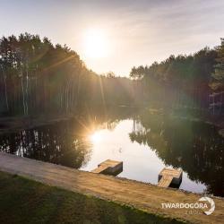
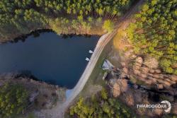
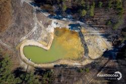
Projekt Małej Retencji Nizinnej realizowanej w Nadleśnictwie Oleśnica Śląska to 31 obiektów retencyjnych, retencjonujących prawie 63 tys. m3 wody.
Koszt realizacji projektu to ponad 3 mln zł, z czego dofinansowanie z Programu Operacyjnego Infrastruktura i Środowisko wyniosło 85%.
Koordynatorem projektu było Centrum Koordynacji Projektów Środowiskowych w Warszawie.
Obiekty retencyjne spełniają przede wszystkim funkcje przyrodnicze np. zwiększają różnorodność przyrodniczą, czy też zwiększają odporność lasu na zmiany klimatyczne.
Ale ważne są również aspekty społeczne: zmniejszanie zagrożenia powodziowego, minimalizowanie skutków suszy, czy też wykorzystanie tych zbiorników wodnych do celów przeciwpożarowych. Obiekty retencyjne powstały na terenie Gmin: Dobroszyce, Zawonia i Twardogóra.
Specyfiką naszych obiektów jest również aspekt historyczny i edukacyjny. Przywracamy pamięć historyczną obiektów, które przed II WŚ świetnie funkcjonowały np. Tartaczek, Złotowskie Młyny, gdzie przed 100 laty z ówczesnego Breslau przyjeżdżały wozy konne przywożąc gości do urokliwie położonej karczmy z daniami z dziczyzny. Niestety obiekty te zostały zniszczone przez żołnierzy sowieckich, a to co nie zostało wtedy zniszczone, zostało nadszarpnięte zębem czasu i obojętności.
Przywracanie tych obiektów Dla Lasu i Dla Ludzi to również olbrzymie koszty, w skali LP to prawie miliard złotych. Nie udałoby się nam zrealizować tych projektów, gdyby nie wsparcie finansowe Wspólnoty Europejskiej.
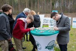
Podczas otwarcia chętni mogli zapoznać się z wystawą prezentującą nasze obiekty retencyjne, ale była również możliwość poznania ich na żywo. Zaproszeni goście uwiecznili ten moment poprzez umieszczenie swojego podpisu na drewnianych liściach, które stworzyły dużo drzewo(zdjęcia). A symbolicznym „przecięciem wstęgi” było wspólne posadzenie drzew.
Lokalizacja:
1 Staw przy Polanie Grochowskiej Grochowo https://maps.app.goo.gl/wwqEL2NUR9ujc6tS7
2 Staw za Polaną Grochowską Grochowo https://maps.app.goo.gl/dogfMsWv6hHMo7us6
3 Staw Długi Zalesie https://maps.app.goo.gl/PrEHa7hegTkGi9xw8
4 Staw Złotowskie Młyny Zalesie https://maps.app.goo.gl/7W3uMaXCHtu314gg7
5 Staw Sosnowy Zamek Myśl. https://maps.app.goo.gl/bhkBSo8MPHY2gdbt8
6 Staw na Potoku Dąbrowa https://goo.gl/maps/MZMfjUQdsZpLJntz8
7 Staw w Goszczu Goszcz https://maps.app.goo.gl/EzJqMTzjLENCtSvPA
8 Staw Nowy Gola Wielka https://maps.app.goo.gl/iRNPAv8V6jD5MmFr6
9 Staw Skrzypowy Gola Wielka https://maps.app.goo.gl/B4MYbRqnAYk2Mzy67
10 Staw Kasztanowy Gola Wielka https://maps.app.goo.gl/W3rWnmsrMzApyKad7
11 Staw przy Piaskowym Moście Gola Wielka https://maps.app.goo.gl/HCUoFzHp73FF4mPA9
12 Staw przy Moście Piecha Dolny Gola Wielka https://maps.app.goo.gl/NQFdPqHHiobJitxA7
13 Staw przy Moście Piecha Górny Gola Wielka https://maps.app.goo.gl/NQFdPqHHiobJitxA7
14 Staw Tartaczek Twardogóra https://maps.app.goo.gl/PU4XjJEQLyrCKc626
15 Staw Suchy Twardogóra https://maps.app.goo.gl/3FYCn7ZjaLT9UpKG7